Tomorrow Was Supposed to Look Different: A GPS Tour of America's Abandoned Futures
Pull off Interstate 4 near Celebration, Florida, and you'll find something Disney never advertised: a monument to the hubris of urban planning. Just a few miles from the Magic Kingdom sits the abandoned shell of Walt Disney's original vision for tomorrow — a city where cars would be banished underground, residents would travel by monorail, and the future would finally look like the future.
Disney's Experimental Prototype Community of Tomorrow (EPCOT) was never built as planned, but its ghost haunts every strip mall and subdivision that took its place. And it's just one stop on America's most instructive road trip: a tour of the futures we were certain we'd be living in by now.
The Digital Map of Abandoned Dreams
Using satellite imagery and historical records, you can plot a route through America's discarded tomorrows. Each coordinate represents a place where visionaries, planners, and dreamers built entire communities around their certainty about what transportation would look like in the future.
Most of them guessed wrong in fascinating ways.
Start your GPS at 28.3182° N, 81.5643° W — Celebration, Florida, the sanitized version of Disney's original car-free vision. From there, drive north to coordinates that will take you through communities that bet everything on monorails, personal flying vehicles, underground highways, and mass transit systems that never materialized.
What these places reveal isn't just the failure of prediction — it's the eternal human tendency to build permanent solutions around temporary technologies.
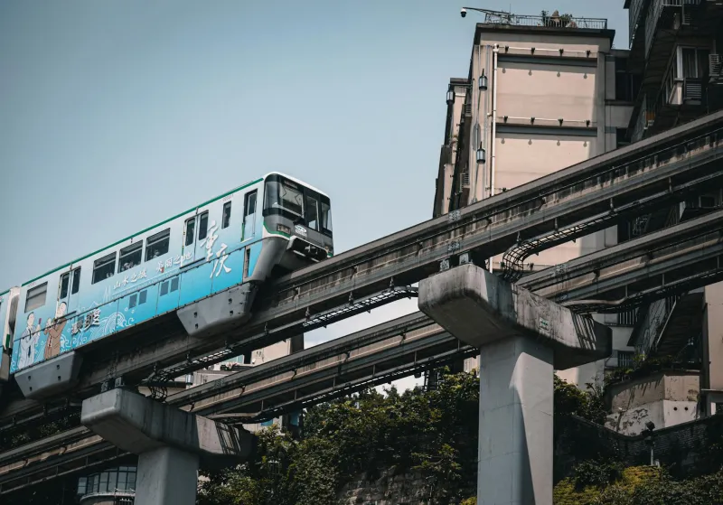
Stop One: The Monorail Graveyard (Morgantown, West Virginia)
Coordinates: 39.6295° N, 79.9559° W
Morgantown's Personal Rapid Transit system was supposed to be the future of urban transportation when it opened in 1975. Small automated cars would whisk passengers along elevated tracks, eliminating traffic jams and parking lots forever. The federal government invested $130 million (about $650 million today) to prove the concept.
Fifty years later, the PRT still runs — sort of. It connects West Virginia University's campus to downtown, carrying about 15,000 riders daily. But instead of spawning a transportation revolution, it became a curiosity. The cars break down regularly, the tracks require constant maintenance, and the system has never expanded beyond its original 8.7-mile route.
Walk through downtown Morgantown today and you'll see the future that didn't happen: empty lots where parking garages were supposed to be unnecessary, street-level businesses that assumed foot traffic from PRT stations that were never built, and residential developments designed around a transportation system that remained perpetually "about to expand."
The lesson isn't that personal rapid transit was a bad idea — it's that building an entire city around any single transportation technology is a gamble with terrible odds.
Stop Two: The Flying Car Capital (Davis, California)
Coordinates: 38.5449° N, 121.7405° W
In 1967, the city of Davis commissioned a comprehensive plan based on the assumption that personal flying vehicles would be common by 1990. The plan included "vertiports" instead of parking lots, residential areas with landing pads instead of driveways, and a downtown designed around the idea that most residents would commute by air.
Davis actually implemented parts of this vision. You can still see the oversized intersections designed to accommodate emergency landings, the unusually wide residential streets planned as backup runways, and the empty lots that were supposed to become vertiports.
What you won't see are flying cars.
Instead, Davis became famous for something its planners never anticipated: bicycles. The wide streets designed for aircraft emergency landings turned out to be perfect for bike lanes. The compact downtown designed to minimize flying distances became ideal for cycling. The city that planned for the Jetsons accidentally created one of America's most bike-friendly communities.
Sometimes wrong predictions create right results, just not for the reasons anyone expected.
Stop Three: The Underground Utopia (Oklahoma City, Oklahoma)
Coordinates: 35.4676° N, 97.5164° W
Beneath downtown Oklahoma City lies one of America's most ambitious failures: a network of underground tunnels that were supposed to revolutionize urban transportation. Built in the 1970s and expanded through the 1990s, the "Underground" was designed to move pedestrians, cars, and eventually mass transit through climate-controlled subterranean spaces.
The vision was compelling: surface streets would be returned to parks and plazas while all transportation happened underground. Office workers would travel from parking garage to office building without ever stepping outside. Shoppers would move between department stores through underground retail corridors.
Today, most of the Underground is abandoned. The pedestrian tunnels flood during heavy rains. The underground parking garages are half-empty because surface parking is cheaper. The retail corridors are lined with vacant storefronts because people prefer shopping at street level.
What killed the Underground wasn't engineering failure — it was psychology. Humans, it turns out, prefer natural light, fresh air, and visual connection to the world around them. The perfectly climate-controlled underground felt less like the future and more like a bunker.
Stop Four: The Car-Free Commune (Arcosanti, Arizona)
Coordinates: 34.3397° N, 112.1089° W
In the Arizona desert, architect Paolo Soleri began building Arcosanti in 1970 as a demonstration of "arcology" — architecture and ecology combined in car-free urban environments. The plan called for a city of 5,000 people living in a compact, walkable community where automobiles would be completely unnecessary.
Fifty years later, Arcosanti houses about 50 residents.
Walking through the partially completed structures, you can see both the vision and its limitations. The buildings are beautiful — flowing concrete forms that integrate with the desert landscape. The urban design is thoughtful — everything within walking distance, communal spaces that encourage interaction, integration with natural systems.
But Arcosanti is also profoundly isolated. Without cars, residents depend on infrequent shuttle service to reach the nearest town. The car-free utopia became car-dependent by necessity, just at a larger scale.
The irony is perfect: a community designed to eliminate automobiles couldn't survive without them.
Stop Five: The Suburban Tomorrow (Reston, Virginia)
Coordinates: 38.9687° N, 77.3411° W
Reston was supposed to prove that suburbs could work without cars. Planned in the 1960s around the assumption that mass transit would connect suburban communities to urban centers, Reston was designed with high-density housing near planned Metro stations, extensive pedestrian paths, and minimal parking.
The Metro didn't arrive until 2014 — nearly 50 years late.
In the meantime, Reston evolved into something its planners never intended: a car-dependent suburb with unusually good walking paths. The high-density housing near the planned Metro stations became high-density housing near crowded parking lots. The pedestrian-friendly design became amenity marketing for residents who still drove everywhere.
When the Metro finally arrived, it validated the original vision — sort of. The areas around Metro stations have become walkable, transit-oriented developments. But most of Reston remains car-dependent, a hybrid of the future that was planned and the present that actually happened.
The Lesson Written in Concrete
Drive through these abandoned futures and you'll notice a pattern: the communities that survived weren't the ones that guessed right about transportation technology — they were the ones that remained adaptable when their guesses proved wrong.
Davis thrived because its infrastructure worked for bicycles when flying cars didn't materialize. Parts of Reston succeeded because buildings designed for Metro riders could accommodate car commuters for 50 years. Morgantown endures because a university campus can support unusual transportation systems that cities can't.
The failures were communities that bet everything on a single technological future: underground cities, car-free communes, monorail networks. When the technology didn't develop as expected, the communities had no backup plan.
Tomorrow's Ruins, Today's Lessons
As you finish this road trip through America's discarded futures, consider what we're building right now around our certainty about tomorrow's transportation. Electric vehicle charging networks, autonomous vehicle infrastructure, bike-share systems — all based on predictions about how Americans will move through space in the coming decades.
Some of these bets will pay off. Others will join the monorail tracks and underground tunnels as monuments to technological optimism. The question isn't whether we'll guess right about the future — it's whether we'll build communities flexible enough to adapt when we guess wrong.
Because if there's one thing America's abandoned utopias teach us, it's this: the future never looks like we think it will, but we keep building it anyway. The ruins scattered across the American landscape aren't failures of engineering — they're evidence of imagination, ambition, and the eternal human habit of mistaking the next big thing for the last big thing.
Your GPS can guide you to these places, but understanding what they mean requires looking beyond the coordinates to the psychology that created them. Every abandoned future is also a map of how we think about tomorrow — and how tomorrow thinks about us.